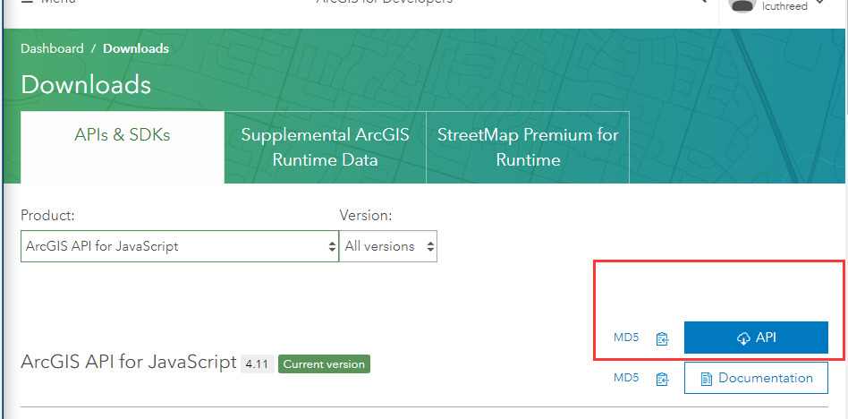
1.下载ArcGIS API(编辑时最新版本为4.11)

2.部署IIS
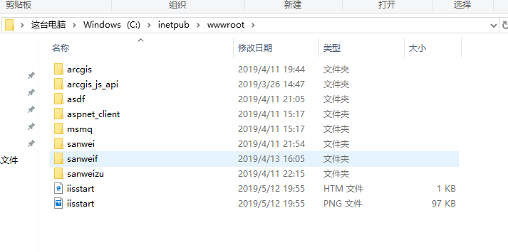
把下载的arcgis api 4.x 离线包解压拷贝到 C:\inetpub\wwwroot 目录下

配置 init.js 文件,修改里面的路径
C:\inetpub\wwwroot\arcgis_js_api\library\4.10\init.js ;
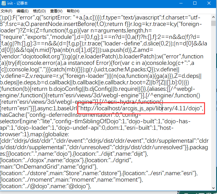
init.js 文件里面,搜索 [HOSTNAME_AND_PATH_TO_JSAPI] ,然后替换成本机的部署路径
例如我的:
http://localhost/arcgis_js_api/library/4.11/dojo

3.检测是否部署成功
编辑一个简单的例子检测是否部署成功。


  1 <!DOCTYPE html>
  2 <html>
  3 <head>
  4     <meta charset="utf-8" />
  5     <meta
  6             name="viewport"
  7             content="initial-scale=1,maximum-scale=1,user-scalable=no"
  8     />
  9     <title>Sketch in 3D - 4.11  已经完成</title>
 10
 11     <link rel="stylesheet" href="http://localhost/arcgis_js_api/library/4.11/esri/css/main.css">
 12     <script src="http://localhost/arcgis_js_api/library/4.11/init.js"></script>
 13     <!--现在定位到了金柱月亮湾B区的位置 有变动再调整!-->
 14     <style>
 15         html,
 16         body,
 17         #viewDiv {
 18             padding: 0;
 19             margin: 0;
 20             height: 100%;
 21             width: 100%;
 22         }
 23
 24         #sketchPanel {
 25             padding: 10px;
 26             background-color: rgba(255, 255, 255, 0.8);
 27         }
 28
 29         .esri-button {
 30             margin: 2px;
 31         }
 32     </style>
 33     <script>
 34         require([
 35             "esri/Map",
 36             "esri/views/SceneView",
 37             "esri/layers/GraphicsLayer",
 38             "esri/widgets/Sketch/SketchViewModel",
 39             "esri/symbols/WebStyleSymbol"
 40         ], function(
 41             Map,
 42             SceneView,
 43             GraphicsLayer,
 44             SketchViewModel,
 45             WebStyleSymbol
 46         ) {
 47             // the layer where the graphics are sketched
 48             const gLayer = new GraphicsLayer();
 49
 50             const map = new Map({
 51                 basemap: "streets",
 52                 layers: [gLayer],
 53                 ground: "world-elevation"
 54             });
 55
 56             const view = new SceneView({
 57                 container: "viewDiv",
 58                 map: map,
 59                 camera: {
 60                     position: [115.960782,36.468442, 273.31548],
 61                     heading: 46.79,
 62                     tilt: 28.35
 63                 }
 64             });
 65
 66             const blue = [82, 82, 122, 0.9];
 67             const white = [255, 255, 255, 0.8];
 68
 69             // polygon symbol used for sketching the extruded building footprints
 70             const extrudedPolygon = {
 71                 type: "polygon-3d",
 72                 symbolLayers: [
 73                     {
 74                         type: "extrude",
 75                         size: 45, // extrude by 10 meters
 76                         material: {
 77                             color: white
 78                         },
 79                         edges: {
 80                             type: "solid",
 81                             size: "3px",
 82                             color: blue
 83                         }
 84                     }
 85                 ]
 86             };
 87
 88             // polyline symbol used for sketching routes
 89             const route = {
 90                 type: "line-3d",
 91                 symbolLayers: [
 92                     {
 93                         type: "line",
 94                         size: "3px",
 95                         material: {
 96                             color: blue
 97                         }
 98                     },
 99                     {
100                         type: "line",
101                         size: "10px",
102                         material: {
103                             color: white
104                         }
105                     }
106                 ]
107             };
108
109             // point symbol used for sketching points of interest
110             const point = {
111                 type: "point-3d",
112                 symbolLayers: [
113                     {
114                         type: "icon",
115                         size: "20px",
116                         resource: { primitive: "kite" },
117                         outline: {
118                             color: blue,
119                             size: "3px"
120                         },
121                         material: {
122                             color: white
123                         }
124                     }
125                 ]
126             };
127
128             // define the SketchViewModel and pass in the symbols for each geometry type
129             const sketchVM = new SketchViewModel({
130                 layer: gLayer,
131                 view: view,
132                 pointSymbol: point,
133                 polygonSymbol: extrudedPolygon,
134                 polylineSymbol: route
135             });
136
137             // add an event listener for the Delete key to delete
138             // the graphics that are currently being updated
139             view.on("key-up", function(evt) {
140                 if (evt.key === "Delete") {
141                     gLayer.removeMany(sketchVM.updateGraphics);
142                     sketchVM.reset();
143                 }
144             });
145
146             // after drawing the geometry, enter the update mode to update the geometry
147             // and the deactivate the buttons
148             sketchVM.on("create", function(event) {
149                 if (event.state === "complete") {
150                     sketchVM.update(event.graphic);
151                     deactivateButtons();
152                 }
153             });
154
155             const drawButtons = Array.prototype.slice.call(
156                 document.getElementsByClassName("esri-button")
157             );
158
159             // set event listeners to activate sketching graphics
160             drawButtons.forEach(function(btn) {
161                 btn.addEventListener("click", function(event) {
162                     deactivateButtons();
163                     event.target.classList.add("esri-button--secondary");
164                     // to activate sketching the create method is called passing in the geometry type
165                     // from the data-type attribute of the html element
166                     sketchVM.create(event.target.getAttribute("data-type"));
167                 });
168             });
169
170             function deactivateButtons() {
171                 drawButtons.forEach(function(element) {
172                     element.classList.remove("esri-button--secondary");
173                 });
174             }
175
176             view.ui.add("sketchPanel", "top-right");
177         });
178     </script>
179 </head>
180
181 <body>
182 <div id="viewDiv"></div>
183 <div id="sketchPanel" class="esri-widget">
184     <button id="extrudedPolygon" data-type="polygon" class="esri-button">
185         绘制建筑物
186     </button>
187     <button id="point" data-type="point" class="esri-button">
188         绘制感兴趣点
189     </button>
190     <button id="line" data-type="polyline" class="esri-button">
191         绘制路线
192     </button>
193 </div>
194 </body>
195 </html>
来源:oschina
链接:https://my.oschina.net/u/4400327/blog/3544455